

Atmospheric Radiation Measurement (ARM)
The
Atmospheric Radiation Measurement (ARM)
user facility is a U.S. Department of Energy (DOE) scientific user facility. ARM provides the climate research community with strategically located in situ (i.e. on site) and
remote sensing
data collected from fixed location, mobile, and aerial observatories. ARM collects, processes, quality-checks, stores, and distributes continuous climate measurements, with many observatories collecting data 24 hours a day.
The ARM user facility is designed to improve the understanding and representation of clouds and
aerosols
in climate and
earth system models,
as well as their interactions and coupling with the Earth’s surface. For over 30 years, ARM’s mission has been to advance a robust
predictive understanding
of Earth’s climate and environmental systems and to inform the development of sustainable solutions to the Nation’s energy and environmental challenges. ARM’s mission is still being executed and continues to strengthen ties between observations and models, including an accelerated application of its data to modeling simulations.
ARM Atmospheric Observatories
Three fixed-location atmospheric observatories represent a broad range of atmospheric conditions. Each observatory is operated
by the Atmospheric Radiation Measurement (ARM) user facility and collects large
amounts of atmospheric data. Scientists use data collected from these observatories
to obtain measurements of
radiative fluxes,
cloud and aerosol properties,
precipitation, and related atmospheric characteristics in diverse climate regimes.
Active Fixed Locations
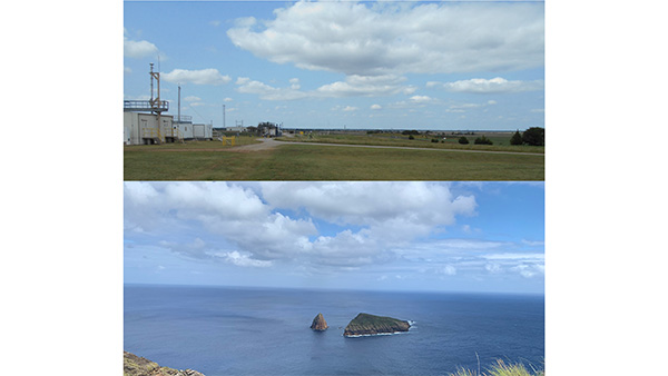
- Southern Great Plains (SGP) – Centered near Lamont, Oklahoma, United States
- North Slope of Alaska (NSA) – Located at Utqiaġvik (formerly Barrow), Alaska, United States
- Eastern North Atlantic (ENA) – Located on Graciosa Island, Azores, Portugal
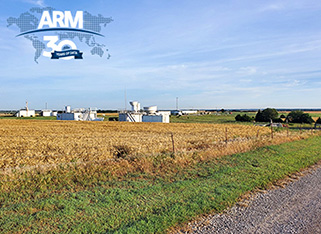
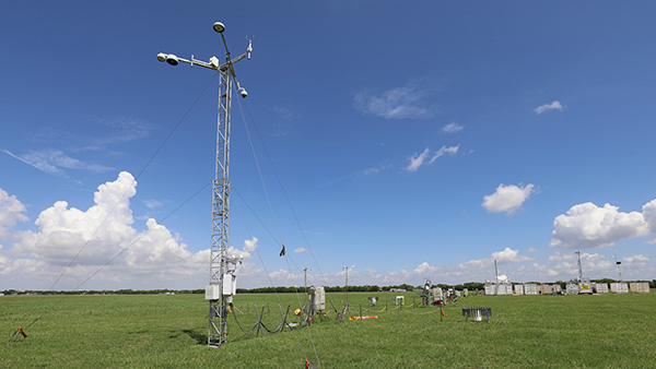
The Southern Great Plains Observatory
Active Mobile and Aerial Observatories
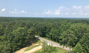
AMF3 scouting visit in Alabama's Bankhead National Forest. The new deployment will study aerosol, cloud, and land-atmosphere interactions.
ARM Mobile Facilities (AMF)
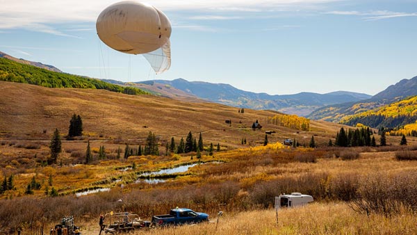
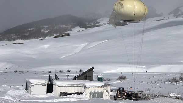
Three AMF are similar to the fixed-location observatories. However, AMF are deployed for periods of about one year at a time anywhere in the world. The second mobile facility (AMF2) was operated at Gunnison, CO from 1 September 2021 - 15 June 2023 (SAIL) and is transitioning to Tasmania, Australia. The third mobile facility (AMF3) was operated at Oliktok Point, Alaska, from September 2013 to June 2021 and is transitioning to the Southeastern United States.
- AMF1 Baltimore, MD - 1 December 2024 - 30 November 2025 (CoURAGE) (Under Construction)
- AMF2 Kennaook/Cape Grim, Tasmania, Australia - 15 April 2024 - 15 September 2025 (CAPE-K)
- AMF3 Bankhead National Forest, AL - 1 September 2023 – 31 August 2028
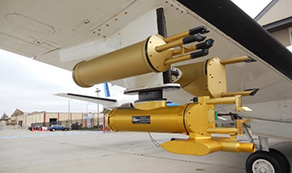
A Bombardier Challenger 850 regional jet fitted with extensive atmospheric data collection sensors
ARM Aerial Facilities (AAF)
ARM AAF collects airborne measurements during intensive field campaigns or long-term, regularly scheduled flights. AAF collects data with crewed aircraft, uncrewed aerial systems, and tethered balloon systems.
Related events
February 2, 2025
–
February 7, 2025
ARM Support for the Australian CAPE-k Student Workshop
The Atmospheric Radiation Measurement (ARM) user facility will co-host a student workshop with the Commonwealth Scientific and Industrial Research Organisation (CSIRO), Australian Bureau of Meteorology (BOM), and a consortium of Australian universities from February 2 to 7, 2025, in Tasmania, Australia. The workshop will focus on open science around ARM’s ongoing Cloud And Precipitation Experiment at kennaook (CAPE-k). Applications are now being accepted for the student workshop, and ARM will sponsor attendance for a few participants.
March 3, 2025
–
March 6, 2025
2025 ARM/ASR Joint Meeting
The Atmospheric Radiation Measurement (ARM)/Atmospheric System Research (ASR) Joint User Facility/Principal Investigator Meeting will be held March 3-6, 2025, at the Rockville Hilton Hotel and Executive Meeting Center in Rockville, Maryland. This meeting will bring together over 300 ASR researchers, ARM users, and ARM infrastructure staff to review progress and discuss scientific priorities for ASR research and the ARM User Facility.
Related news
January 13, 2025
SAIL Campaign, ARM Get Nods on BAMS Cover
The Surface Atmosphere Integrated Field Laboratory (SAIL) campaign and a partner study in Colorado are featured in a new issue of the Bulletin of the American Meteorological Society (BAMS). In its December 2024 print issue, BAMS spotlighted the recent Surface Atmosphere Integrated Field Laboratory (SAIL) campaign conducted in Colorado by the Atmospheric Radiation Measurement (ARM) user facility.
December 4, 2024
ARM 2025 Summer School: Open Science in the Forest
The “Open Science in the Forest Summer School: Connecting State-of-the-Art Models with Diverse Field Campaign Observations” is geared toward students from undergraduates to postdoctoral scholars. Planned activities include instructional talks, tutorials, and mentored hackathon sessions for attendees to work with
ARM data
and open-source software.
December 2, 2024
Brave New CoURAGE Campaign Set to Begin
Do you want more CoURAGE? Atmospheric scientists do, especially those that study climate and weather patterns affecting urban areas around the world. What they have in mind is CoURAGE, the Coast-Urban-Rural Atmospheric Gradient Experiment. This yearlong field campaign in and around Baltimore, Maryland, will begin data collection December 1, 2024.
ARM Operations and Infrastructure
The ARM user facility is a multi-laboratory collaboration that is a key contributor to national and international climate research efforts. ARM operates over 450 instruments on aerial platforms and across six ground-based observatories that collects data to improve our understanding of atmospheric processes and advance Earth system models. All data is freely available to the public. ARM Operations and Infrastructure supports the data analysis needs of researchers in DOE’s Atmospheric System Research program and other climate programs. Our activities encourage and facilitate the use of data, estimate uncertainties in climate models, and improve comparison of models with observations.

ARM Data Center
The ARM Data Center provides a robust, integrated data and computing environment to advance understanding of atmospheric radiation. It currently holds more than 3.5 petabytes of data from over 11,000 sources, including data collected from field campaigns, instruments, and shared by principal investigators. The data center offers computing infrastructure to support next-generation atmospheric model simulations, storage for large files, big-data analytics, and machine learning for atmospheric and climate science research.
ARM Data Products for Modelers
This project supports the data analysis needs of researchers who are creating cloud and climate models in DOE’s Atmospheric System Research program and other climate programs. Our activities encourage and facilitate the use of data, estimate uncertainties in climate models, and improve comparison of models with observations.
ARM Instrument Experts
The Atmospheric Radiation Measurement user facility deploys over 400 instruments across its fixed and mobile facilities. It takes a large (>80) team of instrument experts (what ARM calls Instrument Mentors) across multiple institutions, including national laboratories and universities, to oversee those instruments and ensure that they are producing high-quality data for users of ARM data. Instruments mentors do change from time-to-time so to find the latest information, please visit the ARM mentor list.

ARM Translator Group
The Atmospheric Radiation Measurement user facility is a multi-laboratory collaboration that is a key contributor to national and international climate research efforts. Translators are liaisons between the scientific community and ARM staff. Our work explores radar meteorology, precipitation and cloud radar techniques for estimating rainfall and drop size distributions, and adaptive radar scanning for climate applications.
Atmospheric Radiation Measurement (ARM) User Facility
The Atmospheric Radiation Measurement user facility is a multi-laboratory collaboration that is a key contributor to national and international climate research efforts. We operate over 450 instruments across six ground-based observatories that collect data to improve our understanding of atmospheric processes and advance Earth system models. All data is freely available to the public.
Modeling with ARM Data
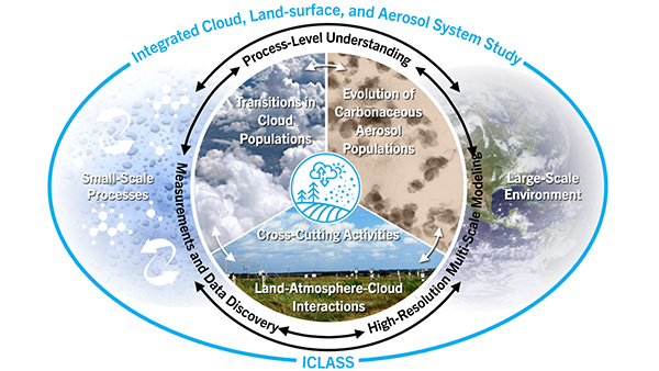
ICLASS: Integrated Cloud, Land-surface, and Aerosol System Study
The ICLASS vision is to transform our understanding of climate processes and provide more robust model representations of the climate system by integrating new knowledge about clouds and aerosols, and their interactions with each other and the Earth’s surface. This approach combines measurements and data discovery with high-resolution multi-scale modeling to advance the fundamental understanding of processes associated with land-atmosphere-cloud interactions, transitions in cloud populations, the evolution of carbonaceous aerosol populations, and aerosol-cloud interactions.
Multiscale Models to Advance the Understanding of Liquid-Phase Cloud Response to Aerosol Perturbation Over Ocean and Land with ARM Data
This DOE Early Career Research Program project aims to study the response of clouds composed of liquid water (as opposed to clouds cold enough to form ice-phase clouds) as they change to air-suspended particles (i.e., aerosols) and reduce the related uncertainty in the DOE Earth system model.
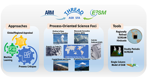
THREAD: Tying in High Resolution E3SM with ARM Data
This project harnesses DOE's recent development of the global storm-resolving model and recent advances in ground-based observations using Atmospheric Radiation Measurement (ARM) data to significantly enhance the predictability of the kilometer-scale Energy Exascale Earth System Model (E3SM). This will be accomplished by diagnosing and improving the representations of clouds, precipitation, and land-atmosphere interaction processes.
Science with ARM Data
Aerosol Regimes and Processes with SAIL Data
This project uses data collected from ground-based instruments and tethered balloon sondes (i.e. tethered weather balloons) in the Colorado East River Watershed Basin to study variability of aerosol processes seasonally. Aerosols are fine solid or liquid particles in a gas and most of the data collected are in situ (in its original place) measurements of different types of aerosols. Our goal is to understand the role of aerosols within mountain hydrology.
Multiscale Models to Advance the Understanding of Liquid-Phase Cloud Response to Aerosol Perturbation Over Ocean and Land with ARM Data
This DOE Early Career Research Program project aims to study the response of clouds composed of liquid water (as opposed to clouds cold enough to form ice-phase clouds) as they change to air-suspended particles (i.e., aerosols) and reduce the related uncertainty in the DOE Earth system model.
THREAD: Tying in High Resolution E3SM with ARM Data
This project harnesses DOE's recent development of the global storm-resolving model and recent advances in ground-based observations using Atmospheric Radiation Measurement (ARM) data to significantly enhance the predictability of the kilometer-scale Energy Exascale Earth System Model (E3SM). This will be accomplished by diagnosing and improving the representations of clouds, precipitation, and land-atmosphere interaction processes.