Probing Water Cycle Processes and Extremes in Coastal and Urban Environments Using Water Isotope Ratio Tracers and Numerical Tags
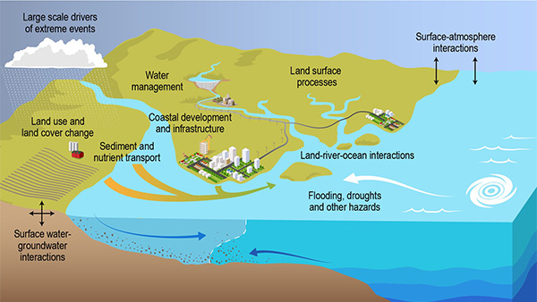
Coasts represent some of the most dynamic and complex natural systems on Earth and are of outsized importance, relative to their area, for national and global economies. Coastal areas face both social and environmental challenges. As more people move to these regions, the risks from extreme weather, rising sea levels,
groundwater
salinization, and
erosion
are increasing due to
climate change.
These intersecting challenges motivate a need for
Earth system models
(ESMs) that can represent coastal systems in detail to better understand the risk to and resilience of coastal cities arising from climate change and increased
urbanization.
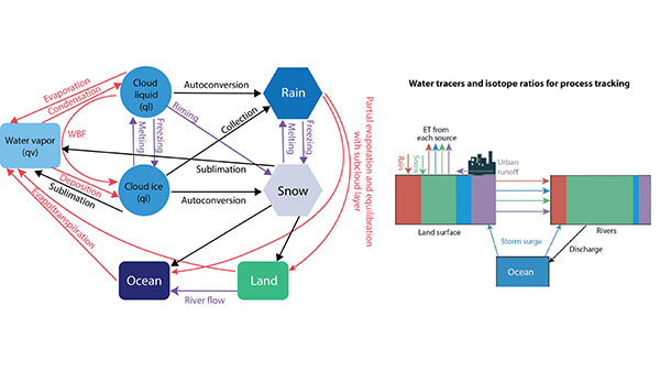
This project will address these limitations by developing a comprehensive water tracking system throughout
E3SM.
The proposed research activities will enhance the E3SM's capability to track water sources, sinks, and transport throughout the hydrological cycle and across model components, ultimately improving our understanding of urban-coastal system interactions. By connecting this new tracking system to the existing capabilities, the enhanced E3SM can be utilized to study coastal change, extreme event susceptibility, and urbanization impacts on precipitation and flooding, and potential solutions for increasing coastal city resilience.
| Keywords | atmospheric modeling, hydroclimate , mesoscale , remote sensing, water cycle, water isotopes |
|---|---|
| TYPE | Early Career |

Schematic of a water isotope ratio and numerical tracer framework for E3SM. (Image Credit: Rich Fiorella, Los Alamos National Laboratory)
Categories


